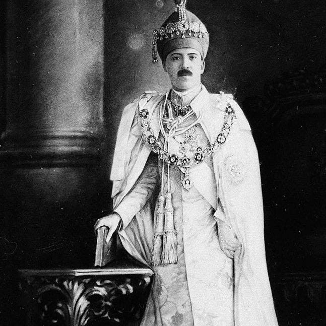
At the time of independence and partition of India, after Kashmir, the princely state which gave the most trouble to India was the State of Hyderabad of His Exalted Highness the Nizam of Hyderabad, Nawab Mir Osman Ali Khan, Asaf Jah VII. Out of almost 565 states, Hyderabad gave the most trouble to India after Kashmir. It was the largest and wealthiest state, with a population of about 16.34 million and an area of 215,339 km², and the Nizam, the ruler of the state, did not accede to India and tried to remain fully independent.
Muslims had penetrated the Deccan region during the reign of Alauddin Khilji (1296–1316), when his general Malik Kafur reached even the great city of Madurai in 1311, deep in southern Peninsular India. Muslim rulers further consolidated their rule a few decades later when, in 1347, Ala-ud-Din Bahman Shah established an independent kingdom with the capital first at Gulbarga and then at Bidar. This kingdom lasted for nearly two centuries and then disintegrated into five successor states: Ahmadnagar, Bidar, Berar, Bijapur, and Golconda. All these states were conquered by Aurangzeb in the late seventeenth century. The last to fall was the Qutb Shahi kingdom of Golconda, which fell with its capital Hyderabad in 1687.
Mughal rule in Hyderabad lasted only three or four decades. With the death of Aurangzeb in 1707, the Mughal Empire went into rapid decline. Mir Qamr-ud-Din Siddiqi, the viceroy, took advantage of the situation and established himself as the independent ruler of the Deccan in 1724, founding the Asaf Jahi dynasty, based in Hyderabad city and controlling vast areas in the Deccan and South India. Militarily, it was never a strong state, and right from the beginning, it depended on the support of first the French and then the British power in India. Ten rulers of this dynasty ruled the state until 1948.
In 1947, Mir Osman Ali Khan was ruling this state. He was confident that with the size and resources of a state like Hyderabad, he could maintain it as an independent country and, unlike other princely states, could avoid joining the Republic of India. Perhaps he did not fully comprehend the geography and demographics of his state and, above all, the winds of change blowing all over India. Indeed, he succeeded for a while, but finally, on 13 September 1948, India invaded the state militarily and occupied it within four days. Under the process of reorganization of Indian states on a linguistic basis, the erstwhile state of Hyderabad was divided among three newly formed Indian states: Andhra Pradesh, Maharashtra, and Karnataka.
In this post, I have presented the details about the demographics of the state. That surely will help in understanding the nature of this state.
No. |
Districts |
Pop. |
Hindus |
% |
Muslims |
% |
Christians |
% |
|
1 |
Hyderabad |
739,159 |
365,823 |
49.49 |
344,915 |
46.66 |
20,839 |
2.82 |
|
2 |
Atraf-i-Balada |
612,493 |
512,401 |
83.66 |
79,011 |
12.90 |
5,476 |
0.89 |
|
3 |
Nizamabad |
647,043 |
552,043 |
85.32 |
62,563 |
9.67 |
12,451 |
1.92 |
|
4 |
Medak |
758,220 |
642,047 |
84.68 |
82,590 |
10.89 |
22,852 |
3.01 |
|
5 |
Baghat* |
90,415 |
77,288 |
85.48 |
11,235 |
12.43 |
1,287 |
1.42 |
|
6 |
Mahbubnagar |
1,088,209 |
930,585 |
85.52 |
99,342 |
9.13 |
5,185 |
0.48 |
|
7 |
Nalgonda |
1,275,352 |
1,089,953 |
85.46 |
83,324 |
6.53 |
25,159 |
1.97 |
|
8 |
Warangal |
1,321,838 |
984,333 |
74.47 |
100,708 |
7.62 |
50,196 |
3.80 |
|
9 |
Karimnagar |
1,355,415 |
1,238,158 |
91.35 |
78,143 |
5.77 |
21,900 |
1.62 |
|
10 |
Adilabad |
823,622 |
633,490 |
76.92 |
54,831 |
6.66 |
9,035 |
1.10 |
|
11 |
Aurangabad |
1,071,950 |
844,421 |
78.77 |
172,211 |
16.07 |
16,716 |
1.56 |
|
12 |
Parbhani |
911,886 |
756,388 |
82.95 |
119,623 |
13.12 |
476 |
0.05 |
|
13 |
Nander |
803,115 |
681,830 |
84.90 |
99,472 |
12.39 |
247 |
0.03 |
|
14 |
Bir |
713,630 |
629,403 |
88.20 |
71,601 |
10.03 |
628 |
1.00 |
|
15 |
Gulbarga |
1,312,055 |
1,028,659 |
78.40 |
230,611 |
17.58 |
7,153 |
0.78 |
|
16 |
Raichur |
1,041,959 |
888,803 |
85.30 |
127,765 |
12.26 |
10,184 |
0.03 |
|
17 |
Osmanabad |
748,691 |
637,400 |
85.14 |
99,563 |
13.30 |
292 |
1.39 |
|
18 |
Bidar |
1,023,482 |
816,624 |
79.79 |
179,967 |
17.58 |
10,388 |
1.01 |
|
Total |
16,338,534 |
13,309,649 |
81.46 |
2,097,475 |
12.84 |
220,464 |
1.35 |
|
*Baghat was a new district and, until 1931, was part of Atraf-i-Balada, when the following map was created.


|
NO |
City |
Pop. |
Hindus |
% |
Muslims |
% |
Christians |
% |
|
1 |
Hyderabad |
739,159 |
370,823 |
50.17 |
344,915 |
46.66 |
29,839 |
4.04 |
|
2 |
Nizamabad |
32,741 |
21,297 |
65.05 |
10,755 |
32.85 |
346 |
1.06 |
|
3 |
Bodhan |
19,443 |
12,324 |
63.39 |
6,580 |
33.84 |
301 |
1.55 |
|
4 |
Medak |
7,565 |
4,275 |
56.51 |
2,036 |
26.91 |
1,253 |
16.56 |
|
5 |
Siddipet |
12,865 |
10,061 |
78.20 |
2,625 |
20.40 |
77 |
0.60 |
|
6 |
Narayanpet |
19,396 |
10,409 |
53.67 |
5,933 |
30.59 |
14 |
0.07 |
|
7 |
Mahbubnagar |
16,462 |
8,921 |
54.19 |
6,861 |
41.68 |
457 |
2.78 |
|
8 |
Nalgonda |
12,674 |
5,708 |
45.04 |
6,269 |
49.46 |
240 |
1.89 |
|
9 |
Bhongir |
12,170 |
8,731 |
71.74 |
6,861 |
56.38 |
49 |
0.40 |
|
10 |
Warangal |
92,808 |
65,769 |
70.87 |
24,181 |
26.05 |
2,430 |
2.62 |
|
11 |
Khammam |
18,982 |
12,401 |
65.33 |
5,391 |
28.40 |
634 |
3.34 |
|
12 |
Yellandu |
15,907 |
11,615 |
73.02 |
1,942 |
12.21 |
634 |
3.99 |
|
13 |
Jagtial |
16,294 |
10,911 |
66.96 |
5,179 |
31.78 |
254 |
1.56 |
|
14 |
Karimnagar |
17,437 |
9,537 |
54.69 |
7,064 |
40.51 |
464 |
2.66 |
|
15 |
Peddapalli |
10,731 |
7,865 |
73.29 |
2,566 |
23.91 |
258 |
2.40 |
|
16 |
Nirmal |
14,499 |
10,046 |
69.29 |
4,387 |
30.26 |
32 |
0.22 |
|
17 |
Adilabad |
11,128 |
7,680 |
69.02 |
3,399 |
30.54 |
- |
0.00 |
|
18 |
Aurangabad |
50,924 |
25,281 |
49.64 |
23,416 |
45.98 |
923 |
1.81 |
|
19 |
Jalna |
38,096 |
23,190 |
60.87 |
14,239 |
37.38 |
1,342 |
3.52 |
|
20 |
Parbhani |
21,683 |
10,340 |
47.69 |
11,060 |
51.01 |
24 |
0.11 |
|
21 |
Hingoli |
14,601 |
9,140 |
62.60 |
5,021 |
34.39 |
20 |
0.14 |
|
22 |
Manwath |
14,113 |
11,287 |
79.98 |
2,545 |
18.03 |
- |
0.00 |
|
23 |
Basmath |
13,796 |
7,809 |
56.60 |
5,891 |
42.70 |
- |
0.00 |
|
24 |
Nander |
36,689 |
17,687 |
48.21 |
17,765 |
48.42 |
147 |
0.40 |
|
25 |
Bir |
15,222 |
9,012 |
59.20 |
5,975 |
39.25 |
43 |
0.28 |
|
26 |
Mominabad |
16,250 |
10,020 |
61.66 |
5,271 |
32.44 |
13 |
0.08 |
|
27 |
Gulbarga |
53,551 |
22,608 |
42.22 |
30,064 |
56.14 |
351 |
0.66 |
|
28 |
Shorapur |
11,836 |
6,729 |
56.85 |
4,974 |
42.02 |
18 |
0.15 |
|
29 |
Yadgir |
17,661 |
9,665 |
54.73 |
7,749 |
43.88 |
6 |
0.03 |
|
30 |
Kalyani |
12,542 |
5,208 |
41.52 |
7,312 |
58.30 |
- |
0.00 |
|
31 |
Aland |
13,041 |
4,568 |
35.03 |
7,282 |
55.84 |
6 |
0.05 |
|
32 |
Shahabad |
10,152 |
6,207 |
61.14 |
3,663 |
36.08 |
64 |
0.63 |
|
33 |
Raichur |
34,972 |
21,398 |
61.19 |
13,016 |
37.22 |
327 |
0.94 |
|
34 |
Kopbal |
13,970 |
7,894 |
56.51 |
5,853 |
41.90 |
26 |
0.19 |
|
35 |
Gadwal |
14,716 |
10,822 |
73.54 |
3,781 |
25.69 |
99 |
0.67 |
|
36 |
Latur |
24,985 |
15,478 |
61.95 |
8,980 |
35.94 |
16 |
0.06 |
|
37 |
Bidar |
20,514 |
6,620 |
32.27 |
13,002 |
63.38 |
801 |
3.90 |
|
38 |
Udgir |
11,238 |
6,101 |
54.29 |
4,725 |
42.04 |
41 |
0.36 |
In 1947, Mir Osman Ali Khan was ruling this state. He was confident that with the size and resources of a state like Hyderabad, he could maintain it as an independent country and, unlike other princely states, avoid joining the Republic of India. Perhaps he did not fully comprehend the geography and demographics of his state and, above all, the winds of change blowing all over India. Indeed, he succeeded for a while, but finally, on 13 September 1948, India invaded the state militarily and occupied it within four days. Under the process of reorganization of Indian states on a linguistic basis, the erstwhile state of Hyderabad was divided among three newly formed Indian states: Andhra Pradesh, Maharashtra, and Karnataka.


After the fall of Mughal Emperor Bahadur Shah Zafar in 1857, the Nizam of Hyderabad was the most prominent symbol of Muslim influence and prestige in India. Reputed to be the richest person in the world, the last Nizam, Mir Osman Ali Khan, made every effort to develop his state. Nearly all the major public buildings and institutions in Hyderabad city, such as Hyderabad High Court, Jubilee Hall, Nizamia Observatory, Moazzam Jahi Market, Kachiguda Railway Station, Asafiya Library, Town Hall (now known as the Assembly Hall), and Hyderabad Museum (now known as the State Museum), as well as hospitals like Osmania General Hospital and Nizamia Hospital, along with many other monuments, were built during his reign. He also built the Hyderabad House in Delhi, which is now used for diplomatic meetings by the Government of India.
I hope this post will be of considerable interest to people who want to learn about the past of this state, which lasted for more than two centuries. Its legacies are still found in the region it once controlled, and their effect on the culture of its people can still be seen.
The way things turned out, i think the best would have been to do the following:
ReplyDelete1. Kashmir should have acceded to pakistan but Maharaja should have been alowed to keep the non muslim majority Jammu and Laddakh in india
2. All the hindus from pakistan, bangladesh and kashmir should have been exchanged for equal number of muslims in india which would have reduced the muslims in india by 10 million in 1951 (there were 9.8 million hindus in pakistan and Bangladesh and 35.4 million muslims in india (including 2.3 million muslims in kashmir) . this means that after the above 2 steps the muslim population would have gone down to 23.3 million.
3. Hyderabad had a population of 17.5 million in 1951 meaning that the state was large enough to accomodate most of the muslims of rest of india however in order to not hit the marathi, telugu and kannada hindus , the state should have been split up with only Bidar, Nander, Gulbarga, Atraf - e - Baladia , Medak and Nizamabad remaining in Hyderabad state while the rest of the state going to india. This would have been large enough to accomodate the muslism of central and most of south india . in lieu of this, the Bareilly division of UP should have been given to the nizam so that the muslims of northern india esp Delhi and UP could have been accomodated there. For sure this would have split hyderabad geographically but on the other hand it would have allowed india to get a better deal in terms of area as barelly division has more or less same population as the areas i proposed to be given to india but its area is much smaller then what india was getting from hyderabad state thus giving some comfort to india.
4. In order for hyderabad to have a port, the muslim majority region of south malabar (calicut and malappapuram dist ) should have been given to hyderabad and this would have accomodated the rest of the muslims of south esp kerala region.
5. Bangladesh, pakistan and Hyderbad should have been separate countries from day one while hyderabad would have included 3 non contigious regions of Bareilly division, malabar and remaining portion of old hyderabad state.
6. rest of the small muslim ruled states like Bhopal, Junagadhm Janjira etc should have remained in india and india in return shoudl have allowed their muslim population to remain as well .
All this would have more or less taken care of population transfers. i. india and pakistan would have had good relations with each other after a mutually decided partition and population transfers
ii. Pakistna and Bangladesh woudl have been friendly as well as they would have avoided the 1971 debacle
iii. muslims of india woudl have also gotten a homleand for them in the form of hyderabad
iv. the sindhi muhajir issue in sindh would have not been there as the muslims of UP , Delhi CP etc (whih form the backbone of muhajir community) would have been living happily in hyderabad state along with their fellow co ethnists.
v. issue of divided families betwen india and pakistan and Bangladesh and the persecution of hindus in pakistan wouldnt have existed.
Assalamualaikum
DeleteWalaikum as salam
Delete