And truly the Grand Trunk Road is a wonderful spectacle. It runs straight, bearing without crowding India’s traffic for fifteen hundred miles—such a river of life as nowhere else exists in the world. They looked at the green-arched, shade-flecked length of it, the white breadth speckled with slow-pacing folk… (Kipling, R., Kim, 1900)
"In 1796, Sayyid Imam ud Din Husaini of Lucknow joined Shah Zaman at Lahore, and followed him in his train to Afghanistan, returning in 1798. His work Tarikh-i-Husain Shahi contains interesting details of the invader's road. In 1797, J. Lumsden, the British Resident at Lucknow, despatched Sheikh Rahim Ali to Kabul, and the best part of his narrative is on the above subject."
|
|
Sarai
Name / Locality |
Distance |
Exact
Location |
Area (Acres) |
State / Province |
|
01 |
Badlki Ki
Sarai |
9 Miles |
28°43'8.76"N, 77°10'3.53"E |
1.6 |
Delhi |
|
02 |
Narela
|
7 Miles |
|
|
Delhi |
|
03 |
Sonipat
|
11 Miles |
|
|
Haryana |
|
04 |
Ganaur
|
10 Miles |
|
|
Haryana |
|
05 |
Samalkha
|
7 Miles |
|
|
Haryana |
|
06 |
Panipat
|
11 Miles |
|
|
Haryana |
|
07 |
Gharaunda
|
11 Miles |
|
|
Haryana |
|
08 |
Karnal
|
10 Miles |
|
|
Haryana |
|
09 |
Taraori /
Azimabad |
8 Miles |
|
|
Haryana |
|
10 |
Thanesar |
13 Miles |
29°58'38.96"N, 76°49'41.71"E |
2.8 |
Haryana |
|
11 |
Shahabad |
|
|
|
Haryana |
|
12 |
Ambala |
17 Miles |
|
|
Haryana |
|
12A |
Sarai Mughal |
|
30°26'7.17"N, 76°41'9.66"E |
2.2 |
Punjab (IN) |
|
13 |
Raja Sarai /
Rajpura |
13 Miles |
|
|
Punjab (IN) |
|
14 |
Sirhind |
15 Miles |
30°38'14.36"N, 76°23'50.24"E |
2.2 |
Punjab (IN) |
|
15 |
Khanna |
11 Miles |
|
|
Punjab (IN) |
|
16 |
Sarai Lashkari
Khan |
9 Miles |
30°45'18.13"N, 76°
5'24.12"E |
6.4 |
Punjab (IN) |
|
16A |
Mughal Sarai,
Doraha |
|
30°47'53.41"N, 76°
1'18.22"E |
7.3 |
Punjab (IN) |
|
17 |
Ludhiana |
18 Miles |
|
|
Punjab (IN) |
|
18 |
Phillaur |
8 Miles |
31° 0'41.83"N, 75°47'23.47"E |
7.5 |
Punjab (IN) |
|
19 |
Sarai Nurmahal |
12 Miles |
31° 5'33.38"N, 75°35'40.17"E |
6 |
Punjab (IN) |
|
20 |
Nakodar Sarai |
8 Miles |
|
|
Punjab (IN) |
|
21 |
Dakhni Sarai |
5 Miles |
31°10'18.75"N, 75°24'41.67"E |
6.6 |
Punjab (IN) |
|
22 |
Tuti Sarai |
12 Miles |
Place Not Identified |
|
Punjab (IN) |
|
23 |
Sultanpur |
12 Miles |
31°12'50.38"N, 75°11'25.87"E |
5 |
Punjab (IN) |
|
24 |
Goindwal |
13 Miles |
|
|
Punjab (IN) |
|
25 |
Aurangabad Sarai |
8 Miles |
Place Not Identified |
|
Punjab (IN) |
|
26 |
Nur ud Din Sarai |
8 Miles |
Place Not Identified |
|
Punjab (IN) |
|
27 |
Sarai Amanat Khan |
11 Miles |
31°30'39.07"N, 74°41'34.93"E |
6.5 |
Punjab (IN) |
|
28 |
Raja Tal |
8 Miles |
|
|
Punjab (IN) |
|
29 |
Khankhanan Sarai |
12 Miles |
|
|
Punjab (PK) |
|
30 |
Lahore |
7 Miles |
|
|
Punjab (PK) |
|
31 |
Akbari Sarai, Shahdara |
4 Miles |
31°37'21.30"N, 74°17'59.26"E |
10 |
Punjab (PK) |
|
32 |
Sarai Fazalabad |
8 Miles |
|
|
Punjab (PK) |
|
33 |
Pul Shah Daula |
10 Miles |
|
|
Punjab (PK) |
|
34 |
Eminabad |
11 Miles |
32° 2'10.51"N, 74°15'41.93"E |
4.3 |
Punjab (PK) |
|
35 |
Sarai Kachchi / Gujar Sarai |
|
|
|
Punjab (PK) |
|
36 |
Sarai Gakhar (Sarai Cheema) |
10 Miles |
|
|
Punjab (PK) |
|
37 |
Nizamabad / Kot Khizri |
6 Miles |
32°22'53.46"N, 74°
7'46.83"E |
7.6 |
Punjab (PK) |
|
38 |
Wazirabad |
4 Miles |
32°27'0.39"N, 74°
6'54.03"E |
7 |
Punjab (PK) |
|
39 |
Gujrat Shah Daula |
9 Miles |
|
|
Punjab (PK) |
|
40 |
Khwaspurah |
11 Miles |
|
|
Punjab (PK) |
|
41 |
Kharian |
12 Miles |
|
|
Punjab (PK) |
|
42 |
Aurangabad |
10 Miles |
|
|
Punjab (PK) |
|
43 |
Jhelum |
2 Miles |
|
|
Punjab (PK) |
|
44 |
Rohtas |
12 Miles |
|
|
Punjab (PK) |
|
44A |
Rajopindi |
|
32°58'58.52"N, 73°33'45.65"E |
6.6 |
Punjab (PK) |
|
45 |
Kasran Sarai |
6 Kos |
Place Not Identified |
|
Punjab (PK) |
|
46 |
Sarai Jalal |
5 Kos |
Place Not Identified |
|
Punjab (PK) |
|
47 |
Dukka Sarai |
6 Kos |
Place Not Identified |
|
Punjab (PK) |
|
48 |
Sara Kala Khan |
6 Kos |
Place Not Identified |
|
Punjab (PK) |
|
49 |
Pakka Sarai |
8 Kos |
33°18'34.67"N, 73°20'31.66"E |
3.8 |
Punjab (PK) |
|
49A |
Rawat |
|
33°29'53.28"N, 73°11'39.33"E |
2.7 |
Islamabad |
|
50 |
Rawalpindi |
4 Kos |
|
|
Punjab (PK) |
|
51 |
Kharpura Sarai / Kharbuza |
4 Kos |
33°40'54.88"N, 72°54'21.65"E |
3.7 |
Islamabad |
|
52 |
Hasan Abdal |
7 Kos |
|
|
Punjab (PK) |
|
53 |
Sarai Meeran |
8 Kos |
Place Not Identified |
|
Punjab (PK) |
|
54 |
Sarai Dangran |
7 Kos |
Place Not Identified |
|
Punjab (PK) |
|
55 |
Shahsabad |
8 Kos |
|
|
Punjab (PK) |
|
56 |
Attock (Begum Ki Sarai) |
10 Kos |
33°53'41.89"N, 72°14'18.63"E |
2.3 |
Punjab (PK) |
|
57 |
Khairabad |
3 Miles |
|
|
Pakhtunkhwa |
|
58 |
Akorah Khattak |
8 Miles |
|
|
Pakhtunkhwa |
|
59 |
Shahabad |
20 Miles |
Place Not Identified |
|
Pakhtunkhwa |
|
60 |
Peshawar |
16 Miles |
34° 0'30.89"N, 71°34'51.34"E |
6.5 |
Pakhtunkhwa |
|
61 |
Jamrud |
11 Miles |
|
|
Pakhtunkhwa |
|
62 |
Ali Masjid |
10 Miles |
|
|
Pakhtunkhwa |
|
63 |
Fort of Lal Bag |
|
Place Not Identified |
|
|
|
64 |
Dakka |
12 Miles |
|
|
Afghanistan |
|
65 |
Isuali |
13 Miles |
Place Not Identified |
|
Afghanistan |
|
66 |
Jalalabad |
30 Miles |
|
|
Afghanistan |
|
67 |
Charbagh |
10 Miles |
|
|
Afghanistan |
|
68 |
Fatahabad |
8 Miles |
Place Not Identified |
|
Afghanistan |
|
69 |
Nimlah Bagh |
10 Miles |
34°17'47.05"N, 70°
6'4.11"E |
33.7 |
Afghanistan |
|
70 |
Gandamak |
8 Miles |
|
|
Afghanistan |
|
71 |
Surkhab |
8 Miles |
Place Not Identified |
|
Afghanistan |
|
72 |
Jagdalak |
16 Miles |
|
|
Afghanistan |
|
73 |
Barikab |
17 Miles |
Place Not Identified |
|
Afghanistan |
|
74 |
Buthak |
16 Miles |
Place Not Identified |
|
Afghanistan |
|
75 |
Kabul |
12 Miles |
|
|
Afghanistan |


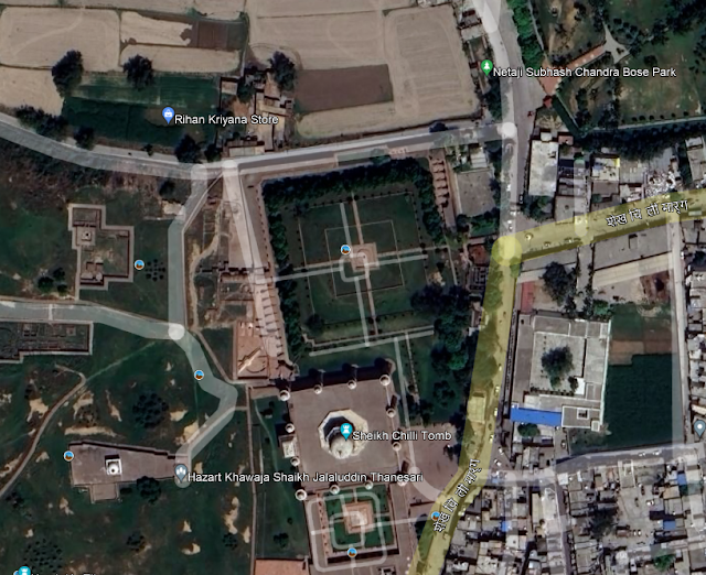
10. Sarai at Thanesar (29°58'38.96"N, 76°49'41.71"E)


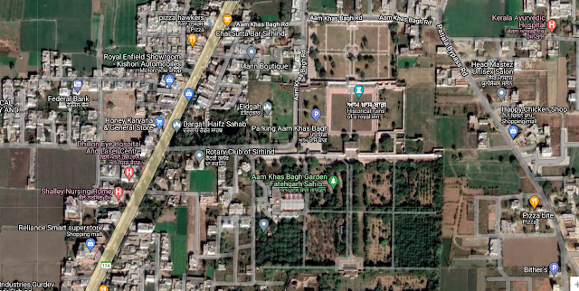
14. Aam Khas Bagh Sarai - Sirhind (30°38'14.36"N, 76°23'50.24"E)


18. Phillaur (31° 0'41.83"N, 75°47'23.47"E)


19. Sarai Nurmahal (31° 5'33.38"N, 75°35'40.17"E)


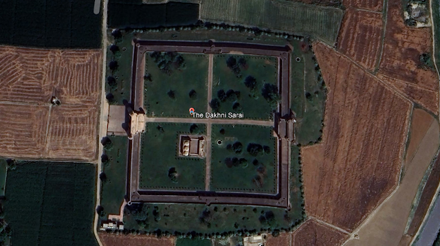
21. Dakhani Sarai (31°10'18.75"N, 75°24'41.67"E)


37. Kot Khizri / Nizamabad (32°22'53.46"N, 74° 7'46.83"E)

38. Wazirabad (32°27'0.39"N, 74° 6'54.03"E)

44A. Rajopindi (32°58'58.52"N, 73°33'45.65"E)


51. Sarai Kharbuza (33°40'54.88"N, 72°54'21.65"E)


56. Begum Ki Sarai (33°53'41.89"N, 72°14'18.63"E)

60. Gor Khatri, Peshawar (34° 0'30.89"N, 71°34'51.34"E)


69. Nimlah Bagha (Mimla / Mimli Bagh) - (34°17'47.05"N, 70° 6'4.11"E)


We’re marchin’ on relief over Inija’s sunny plains,
A little front o’ Christmas-time an’ just be’ind the Rains;
Ho! get away you bullock-man, you’ve ‘eard the bugle blowed,
There’s a regiment a-comin’ down the Grand Trunk Road;
Rudyard Kipling