Aryans migrated to India around 1500 BC and made the Indus Valley their home. For the next few centuries they settled in the river valleys of Punjab, before spreading towards Ganges plains. This period is called Vedic period, as the holy scriptures of the Hindu religion, known as Vedas, were written during this time. This area hence became the cradle of Hindu civilization. For the next 25 centuries it was an important area of Hindu culture and religion, until the arrival of Muslim by the end of the 10th century AD.
During this time many cities were built by them, with great temples as symbols of religion and culture. Some of the ruins of those ancient cities can be seen in the Salt Range, at Nandana, Malot, Amb and Mari Indus. (For Malot and Amb see my previous posts). In addition to that there are temples at Kafir Kot and Bilout, in district Dera Ismail Khan, which are considered to be extension of the Salt Range Temples. During my recent visit to these two places I found them to be best of all temples of Salt Range.
I seldom venture out of Punjab during my excursions, so entering Khyber Pakhutnkhwa was an additional excitement. Though I was not expecting anything extraordinary, but frankly speaking I was looking forward to a few glimpses of hardy Pathans with Kalashnikovs. I also regretted my inability to speak or understand any Pashto. But to my surprise all were speaking in Punjabi or Seraiki as they call it. But the same language we speak in my native town, Lilla in tehsil Pind Dadan Khan. First I thought I have met labourers from Punjab, but soon realized that the whole population along the river Indus speaks Seraiki / Punjabi. (They call it Seraiki).
My cousin Shah Sultan of Nali, District Khushab was with me, along with another companion. We entered KP after crossing the river Indus at Chashma barrage. Huge amount of water was gushing through the gates of the barrage with a big roar. The road passes right above the barrage.
My cousin Shah Sultan of Nali, District Khushab was with me, along with another companion. We entered KP after crossing the river Indus at Chashma barrage. Huge amount of water was gushing through the gates of the barrage with a big roar. The road passes right above the barrage.
After crossing the barrage we turned right (northwards) towards Kafir Kot our first point of interest. The distance of Kafir Kot is 7.3 kilometers from this turning. Soon we were on an almost deserted road winding past hills on left side and high banks of the bed of river Indus on right. Contrary to my expectations it proved to be a little difficult to locate Kafir Kot, despite having already marked the place on google maps. Actually it is on top of the hills and not visible from the road. However, a few labourers were clearing the debris on the road, result of recent rains and they showed us a winding path up the hill top. The track was constructed just a couple of years back, according to a local man, but now the lower half is completely destroyed by heavy rains and is nothing now but a heap of loose stones. The first one third of the distance is particularly very difficult but rest of the path is easier to travel on. We parked our car beside the road and walked up the track. The distance from here to the gate of the city is approximately 630 m. It was a cloudy and hazy, but humid day. Not suitable for photography.
What we saw on the top of a plateau type hill was nothing less than a complete surprise. I was expecting just ruins of a couple of old temples, but what we saw was a complete fortified city, with large parts of the walls intact. Similarly at least two of the four or five temples are in a good condition, considering that they are more than 1,000 years old.


What we saw on the top of a plateau type hill was nothing less than a complete surprise. I was expecting just ruins of a couple of old temples, but what we saw was a complete fortified city, with large parts of the walls intact. Similarly at least two of the four or five temples are in a good condition, considering that they are more than 1,000 years old.

Track to Kafir Kot. (13.08.2015.)

River Indus. (13.08.2015.)

Walls of Kaifr Kot. (13.08.2015.)

Bastions and walls of Kafir Kot. (13.08.2015.)

Approaching Kafir Kot. (13.08.2015.)

Probably the main gate of Kafir Kot. (13.08.2015.)

Stone work around the gate reminded me of ancient historic cities in South America. (13.08.2015.)

View of the two main temples from the East. (13.08.2015.)

Wall of the city. (13.08.2015.)

One of the two best preserved temples. (13.08.2015.)

View from the front. (13.08.2015.)

Another view of the first temple. (13.08.2015.)

The second temple. (13.08.2015.)

An enclosure and platform of the third temple. (13.08.2015.)

View of the two temples from the west. (13.08.2015.)

Two structures on the western edge of the city of Kafir Kot. (13.08.2015.)

Probably the largest temple in the city. (13.08.2015.)

View from the front. (13.08.2015.)

A structure at the western most edge of the city. (13.08.2015.)

View of a branch of Indus. (13.08.2015.)

A fifth small building on higher ground, in the southern part of the city. (13.08.2015.)
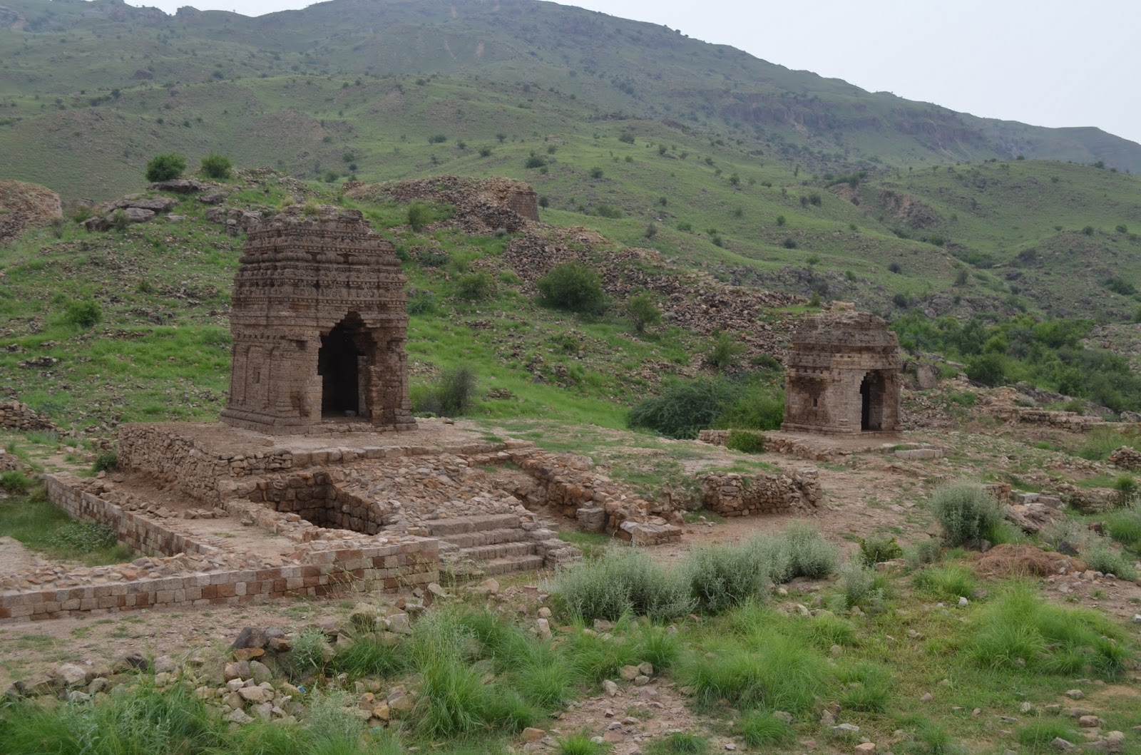
A parting shot of the two temples. (13.08.2015.)
Even a layman like me soon realized that this is a no ordinary place. It is a huge archaeological site, with an area of approximately 27 acres and circumference of 1.6 Kms, about 70 meters above the road. It is also evident that it has never been properly excavated or explored. Though we saw a few signs of attempts on preservation but saw no evidence of a large scale restoration work. Neither we saw any board providing any details of this site. We strolled around the ruins for nearly an hour and took some pictures.
Our next destination was Bilout temples, about 35 kilometers in south, towards Dera Ismail Khan city. We reached there in half an hour and found that this site is also located on a hill, nearly 60 meters above the nearby ground. In additional problem was the flooded plains between the road and the hills. We luckily found an opening and reached the base of the hills. I was already tired by my mountain climbing at Kafir Kot, so it proved to me more difficult. As there was no proper track leading to the top. Perhaps the better way is to approach it through eastern side from the Bilout town. Yes unlike Kafir Kot, a thriving small town exists just east of this site.
The similarities between the two sites are great, which clearly indicate that both were inhabited in the same time and by the same civilization. This city though smaller in size with an area of approximately 21 acres and circumference of 1.4 Kms, houses bigger and more beautifully constructed temples. The number of structures here is about seven.

Flooded plains near Bilout. (13.08.2015.)

Parts of the ancient city of Bilout. (13.08.2015.)

Temples complex from a distance. (13.08.2015.)

Two temple. (13.08.2015.)

A square building surrounded by ruins of small houses. (13.08.2015.)

Twin temples facing each other. (13.08.2015.)

See two persons on top for scale. (13.08.2015.)

A partially destroyed structure. (13.08.2015.)

A row of temples, along the western wall of the temple. (13.08.2015.)

Front view of a temple. (13.08.2015.)

Another set of twin temples. (13.08.2015.)

Another view. (13.08.2015.)


A destroyed temple. (13.08.2015.)


Platform of a temple. (13.08.2015.)

A herd of goat on the slopes on the way downward. (13.08.2015.)
These two cities of Hindu Shahi era are truly a fascinating sites. I wonder why these have not drawn more attention of local or international archaeologists. These two sites, along with other similar sites in the Salt Range can be easily developed as tourist sites. If you ever plan to visit these places, the map given below will help you in reaching there.
Tariq Amir
November 11, 2015.
Doha - Qatar.
Tariq Amir
November 11, 2015.
Doha - Qatar.