The Grand Trunk Road, running from Kabul in the rugged Hindu Kush mountains to Sonargaon in the verdant plains of Bengal, is definitely among the most famous highways in the world, if not the most famous. Let me add here that several termination points of this great thoroughfare are given in Bengal, including Teknaf. It covers a distance of almost 2,400 km, running through the entire width of Punjab and the Indo-Gangetic plain. Along its course, it connects hundreds of historically and commercially important towns and cities and crosses dozens of mighty rivers.
As Rome was not built in a day, similarly, this great road was not built in one go. The existence of a grand road is mentioned in many sources, which record its presence in some form since 500 BC. Two centuries later, Chandragupta Maurya and later his grandson Ashoka were credited with building and then improving this road. However, many centuries later, Sher Shah Suri (1486–1545 AD) earned the reputation of its true builder by systematically improving the quality and the facilities provided along the way. He is especially praised for constructing sarais, protected halting places with excellent facilities like accommodation, food, water, fodder, and above all, security. During the Mughal period, the standard and the number of sarais further increased, along with shady trees, baolis (step wells), and kos minars.
No government could ignore the importance of this vital road. Years later, the famous English poet and writer Rudyard Kipling noted its significance in the following words:
And truly the Grand Trunk Road is a wonderful spectacle. It runs straight, bearing without crowding India’s traffic for fifteen hundred miles—such a river of life as nowhere else exists in the world. They looked at the green-arched, shade-flecked length of it, the white breadth speckled with slow-pacing folk… (Kipling, R., Kim, 1900)
"In 1796, Sayyid Imam ud Din Husaini of Lucknow joined Shah Zaman at Lahore, and followed him in his train to Afghanistan, returning in 1798. His work Tarikh-i-Husain Shahi contains interesting details of the invader's road. In 1797, J. Lumsden, the British Resident at Lucknow, despatched Sheikh Rahim Ali to Kabul, and the best part of his narrative is on the above subject."
|
|
Sarai
Name / Locality |
Distance |
Exact
Location |
Area (Acres) |
State / Province |
|
01 |
Badlki Ki
Sarai |
9 Miles |
28°43'8.76"N, 77°10'3.53"E |
1.6 |
Delhi |
|
02 |
Narela
|
7 Miles |
|
|
Delhi |
|
03 |
Sonipat
|
11 Miles |
|
|
Haryana |
|
04 |
Ganaur
|
10 Miles |
|
|
Haryana |
|
05 |
Samalkha
|
7 Miles |
|
|
Haryana |
|
06 |
Panipat
|
11 Miles |
|
|
Haryana |
|
07 |
Gharaunda
|
11 Miles |
|
|
Haryana |
|
08 |
Karnal
|
10 Miles |
|
|
Haryana |
|
09 |
Taraori /
Azimabad |
8 Miles |
|
|
Haryana |
|
10 |
Thanesar |
13 Miles |
29°58'38.96"N, 76°49'41.71"E |
2.8 |
Haryana |
|
11 |
Shahabad |
|
|
|
Haryana |
|
12 |
Ambala |
17 Miles |
|
|
Haryana |
|
12A |
Sarai Mughal |
|
30°26'7.17"N, 76°41'9.66"E |
2.2 |
Punjab (IN) |
|
13 |
Raja Sarai /
Rajpura |
13 Miles |
|
|
Punjab (IN) |
|
14 |
Sirhind |
15 Miles |
30°38'14.36"N, 76°23'50.24"E |
2.2 |
Punjab (IN) |
|
15 |
Khanna |
11 Miles |
|
|
Punjab (IN) |
|
16 |
Sarai Lashkari
Khan |
9 Miles |
30°45'18.13"N, 76°
5'24.12"E |
6.4 |
Punjab (IN) |
|
16A |
Mughal Sarai,
Doraha |
|
30°47'53.41"N, 76°
1'18.22"E |
7.3 |
Punjab (IN) |
|
17 |
Ludhiana |
18 Miles |
|
|
Punjab (IN) |
|
18 |
Phillaur |
8 Miles |
31° 0'41.83"N, 75°47'23.47"E |
7.5 |
Punjab (IN) |
|
19 |
Sarai Nurmahal |
12 Miles |
31° 5'33.38"N, 75°35'40.17"E |
6 |
Punjab (IN) |
|
20 |
Nakodar Sarai |
8 Miles |
|
|
Punjab (IN) |
|
21 |
Dakhni Sarai |
5 Miles |
31°10'18.75"N, 75°24'41.67"E |
6.6 |
Punjab (IN) |
|
22 |
Tuti Sarai |
12 Miles |
Place Not Identified |
|
Punjab (IN) |
|
23 |
Sultanpur |
12 Miles |
31°12'50.38"N, 75°11'25.87"E |
5 |
Punjab (IN) |
|
24 |
Goindwal |
13 Miles |
|
|
Punjab (IN) |
|
25 |
Aurangabad Sarai |
8 Miles |
Place Not Identified |
|
Punjab (IN) |
|
26 |
Nur ud Din Sarai |
8 Miles |
Place Not Identified |
|
Punjab (IN) |
|
27 |
Sarai Amanat Khan |
11 Miles |
31°30'39.07"N, 74°41'34.93"E |
6.5 |
Punjab (IN) |
|
28 |
Raja Tal |
8 Miles |
|
|
Punjab (IN) |
|
29 |
Khankhanan Sarai |
12 Miles |
|
|
Punjab (PK) |
|
30 |
Lahore |
7 Miles |
|
|
Punjab (PK) |
|
31 |
Akbari Sarai, Shahdara |
4 Miles |
31°37'21.30"N, 74°17'59.26"E |
10 |
Punjab (PK) |
|
32 |
Sarai Fazalabad |
8 Miles |
|
|
Punjab (PK) |
|
33 |
Pul Shah Daula |
10 Miles |
|
|
Punjab (PK) |
|
34 |
Eminabad |
11 Miles |
32° 2'10.51"N, 74°15'41.93"E |
4.3 |
Punjab (PK) |
|
35 |
Sarai Kachchi / Gujar Sarai |
|
|
|
Punjab (PK) |
|
36 |
Sarai Gakhar (Sarai Cheema) |
10 Miles |
|
|
Punjab (PK) |
|
37 |
Nizamabad / Kot Khizri |
6 Miles |
32°22'53.46"N, 74°
7'46.83"E |
7.6 |
Punjab (PK) |
|
38 |
Wazirabad |
4 Miles |
32°27'0.39"N, 74°
6'54.03"E |
7 |
Punjab (PK) |
|
39 |
Gujrat Shah Daula |
9 Miles |
|
|
Punjab (PK) |
|
40 |
Khwaspurah |
11 Miles |
|
|
Punjab (PK) |
|
41 |
Kharian |
12 Miles |
|
|
Punjab (PK) |
|
42 |
Aurangabad |
10 Miles |
|
|
Punjab (PK) |
|
43 |
Jhelum |
2 Miles |
|
|
Punjab (PK) |
|
44 |
Rohtas |
12 Miles |
|
|
Punjab (PK) |
|
44A |
Rajopindi |
|
32°58'58.52"N, 73°33'45.65"E |
6.6 |
Punjab (PK) |
|
45 |
Kasran Sarai |
6 Kos |
Place Not Identified |
|
Punjab (PK) |
|
46 |
Sarai Jalal |
5 Kos |
Place Not Identified |
|
Punjab (PK) |
|
47 |
Dukka Sarai |
6 Kos |
Place Not Identified |
|
Punjab (PK) |
|
48 |
Sara Kala Khan |
6 Kos |
Place Not Identified |
|
Punjab (PK) |
|
49 |
Pakka Sarai |
8 Kos |
33°18'34.67"N, 73°20'31.66"E |
3.8 |
Punjab (PK) |
|
49A |
Rawat |
|
33°29'53.28"N, 73°11'39.33"E |
2.7 |
Islamabad |
|
50 |
Rawalpindi |
4 Kos |
|
|
Punjab (PK) |
|
51 |
Kharpura Sarai / Kharbuza |
4 Kos |
33°40'54.88"N, 72°54'21.65"E |
3.7 |
Islamabad |
|
52 |
Hasan Abdal |
7 Kos |
|
|
Punjab (PK) |
|
53 |
Sarai Meeran |
8 Kos |
Place Not Identified |
|
Punjab (PK) |
|
54 |
Sarai Dangran |
7 Kos |
Place Not Identified |
|
Punjab (PK) |
|
55 |
Shahsabad |
8 Kos |
|
|
Punjab (PK) |
|
56 |
Attock (Begum Ki Sarai) |
10 Kos |
33°53'41.89"N, 72°14'18.63"E |
2.3 |
Punjab (PK) |
|
57 |
Khairabad |
3 Miles |
|
|
Pakhtunkhwa |
|
58 |
Akorah Khattak |
8 Miles |
|
|
Pakhtunkhwa |
|
59 |
Shahabad |
20 Miles |
Place Not Identified |
|
Pakhtunkhwa |
|
60 |
Peshawar |
16 Miles |
34° 0'30.89"N, 71°34'51.34"E |
6.5 |
Pakhtunkhwa |
|
61 |
Jamrud |
11 Miles |
|
|
Pakhtunkhwa |
|
62 |
Ali Masjid |
10 Miles |
|
|
Pakhtunkhwa |
|
63 |
Fort of Lal Bag |
|
Place Not Identified |
|
|
|
64 |
Dakka |
12 Miles |
|
|
Afghanistan |
|
65 |
Isuali |
13 Miles |
Place Not Identified |
|
Afghanistan |
|
66 |
Jalalabad |
30 Miles |
|
|
Afghanistan |
|
67 |
Charbagh |
10 Miles |
|
|
Afghanistan |
|
68 |
Fatahabad |
8 Miles |
Place Not Identified |
|
Afghanistan |
|
69 |
Nimlah Bagh |
10 Miles |
34°17'47.05"N, 70°
6'4.11"E |
33.7 |
Afghanistan |
|
70 |
Gandamak |
8 Miles |
|
|
Afghanistan |
|
71 |
Surkhab |
8 Miles |
Place Not Identified |
|
Afghanistan |
|
72 |
Jagdalak |
16 Miles |
|
|
Afghanistan |
|
73 |
Barikab |
17 Miles |
Place Not Identified |
|
Afghanistan |
|
74 |
Buthak |
16 Miles |
Place Not Identified |
|
Afghanistan |
|
75 |
Kabul |
12 Miles |
|
|
Afghanistan |


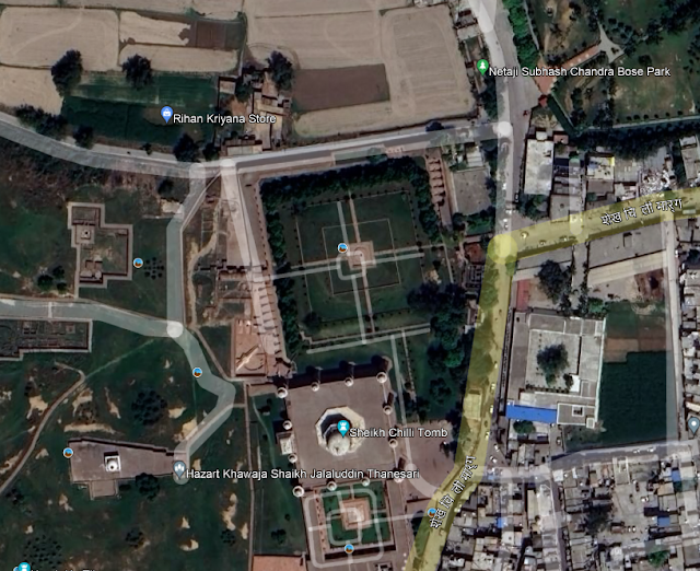
10. Sarai at Thanesar (29°58'38.96"N, 76°49'41.71"E)


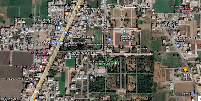
14. Aam Khas Bagh Sarai - Sirhind (30°38'14.36"N, 76°23'50.24"E)


18. Phillaur (31° 0'41.83"N, 75°47'23.47"E)


19. Sarai Nurmahal (31° 5'33.38"N, 75°35'40.17"E)


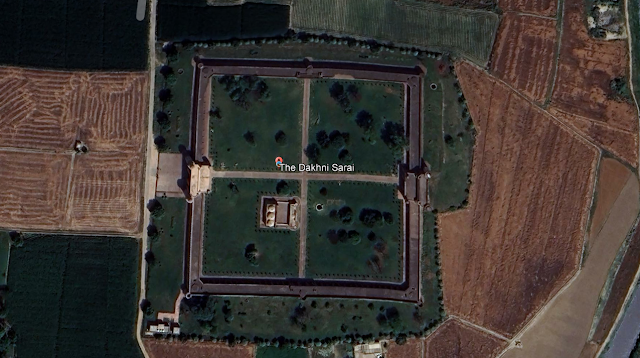
21. Dakhani Sarai (31°10'18.75"N, 75°24'41.67"E)


37. Kot Khizri / Nizamabad (32°22'53.46"N, 74° 7'46.83"E)

38. Wazirabad (32°27'0.39"N, 74° 6'54.03"E)

44A. Rajopindi (32°58'58.52"N, 73°33'45.65"E)


51. Sarai Kharbuza (33°40'54.88"N, 72°54'21.65"E)


56. Begum Ki Sarai (33°53'41.89"N, 72°14'18.63"E)

60. Gor Khatri, Peshawar (34° 0'30.89"N, 71°34'51.34"E)


69. Nimlah Bagha (Mimla / Mimli Bagh) - (34°17'47.05"N, 70° 6'4.11"E)


We’re marchin’ on relief over Inija’s sunny plains,
A little front o’ Christmas-time an’ just be’ind the Rains;
Ho! get away you bullock-man, you’ve ‘eard the bugle blowed,
There’s a regiment a-comin’ down the Grand Trunk Road;
Rudyard Kipling