Rohtas is a village in District Jhelum, just 10 kilometers south of Dina, a town on the GT Road. It is famous for the fort built here by the great king Sher Shah Suri in the mid-16th century. I, too, knew Rohtas only for this fort. While trying to find more about the fort, I discovered that besides this great fort, Rohtas has some other historic monuments as well.
Two of these three sites are historically and religiously very important Gurdwaras—Gurdwara Choa Sahib and Gurdwara Mata Kaur Ji. Hence, it is a significant place for Sikhs from a religious point of view. The third is a tomb built during the Mughal era of a princess, Khair-un-Nissa.
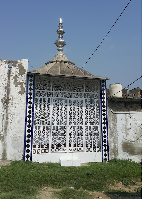
After entering the fort through Khwas Khani Gate, my cousin Nasir Mehmood and I reached the populated part of the fort. There, we asked people about a Sikh Gurdwara. They told us to see Bhola, who runs a tyre repair shop under a tree near a mosque. Bhola turned out to be the caretaker of Gurdwara Mata Kaur Ji. It is a small, beautiful gurdwara that has recently been renovated by a person named Gurbachan Singh, who lives in some foreign country but frequently visits this place. He has appointed Bhola as the caretaker. The gurdwara is a small, one-room building but very beautifully decorated.
Now something about Mata Kaur Ji. She was born in Rohtas in 1681 into a religious family and had great devotion to Guru Gobind Ji. Her father wanted her to marry Guru Ji, but as Guru Gobind Ji was already married, she decided to serve and accompany him throughout his life. Observing her great devotion, Guru Ji declared her the Mother of all Khalsa. Thus, she holds a very respectful position in the Sikh faith, and all Sikhs consider her the mother of their nation. She led them through many crises and died in 1747. (For more details, see Sikhiwiki.)

Gurdwara Mata Kaur ji, before renovation. (Picture: Sikhiwiki.org)
Entrance of the Gurdwara Mata Kaur ji, (18.08.2015.)
Ceiling of the gurdwara Mata Kaur ji. (18.08.2015.)
Engraving of Harmandir Sahib. (18.08.2015.)
Decoration on the left wall. (18.08.2015.)
A picture of the ten Sikh Gurus. (18.08.2015.)
Ghulam Mustafa, aka Bhola, the caretaker of the Gurdwara Mata Kaur ji. (18.08.2015.)
Bhola opened the door of the gurdwara and let us enter and take pictures. He took off his shoes at the door, and we also followed him and entered the room after removing our shoes. The gurdwara is a small but very beautifully decorated room, with beautiful tile work on the walls and roof, and also many pictures of Sikh holy places and gurus. The gurdwara is located at 32°58'5.66"N, 73°34'41.48"E.
Now something about Bhola (in Urdu and Punjabi, simple or naive). Though not rich or well‑educated, he is a gentleman. I did not see an iota of greed or cleverness in his conduct. He performs his duty of taking care of Gurdwara Mata Kaur Ji with honesty and sincerity. But I shall write more about him later on.
Our next point of interest was an old, historic gurdwara associated with Baba Guru Nanak Dev Ji, who was born in Nankana Sahib in 1469 and died at Kartarpur, near Shakargarh, in 1539. Guru Ji spent his whole life preaching love of humanity, tolerance, and harmony between the followers of different religions. To learn and preach, he travelled extensively throughout all of India and beyond. He is said to have even visited Makkah and Medina. During one of those travels, he came to Rohtas. The place where he stayed and prayed became holy for Sikhs, and they constructed a gurdwara to commemorate his visit. Sikhs occupied Rohtas in 1765 and probably constructed a simple gurdwara soon after that, but the current building was constructed in 1834 during the rule of Maharaja Ranjit Singh (https://www.allaboutsikhs.com/gurudwaras-in-pakistan/gurudwara-chowa-sahib-at-rohtas-distt-jhelum).
Gurdwara Choa Sahib is located just outside the Talaqi Gate of Rohtas Fort, at 32°58'16.49"N, 73°34'23.75"E. When we reached the fort we told our guide, who was lurking in the parking lot and immediately offered his services to us, to cut his lecture on the legends of Rohtas Fort short and take us straight to the gurdwara. While passing through Chand Wali Gate and seeing the haveli of Man Singh and Rani Mahal, we proceeded towards Talaqi Gate. The whole path from Rani Mahal onwards to the gate, almost half a kilometer, was totally covered with wild thorny plants and bushes. I expressed my doubt and repeated my intended destination, but the guide assured me that we were on the right path. When we reached Talaqi Gate, we indeed saw the gurdwara right in front of us, but there was a precipice staring at us with a sheer fall of at least 30 meters or perhaps more. We had no other option but to return. The return journey in the hot, suffocating weather itself was a big challenge.
After seeing a few more parts of the fort, we again came to Bhola and asked him to take us to Gurdwara Choa Sahib. He readily agreed. We came out of the fort through Khwas Khani Gate and turned left on a track along the walls of the fort. The gurdwara is exactly 1 kilometer from the gate. The path is very bad and stony. Bhola told us that it was reasonably good, but recent heavy rains have damaged it. We had to park our car halfway to the gurdwara. The building of the gurdwara is in reasonably good condition. Bhola told us that Sikh yatrees occasionally come to visit this place, especially on an annual festival when they come in hundreds.
The gurdwara is located between the River Ghan and Rohtas Fort. It has three storeys. Though there are no religious articles of Sikh faith in the gurdwara, it is in good condition, and sometimes Sikhs come here to visit it and offer their prayers. However, the Sarovar beside the gurdwara is not in good shape. Bhola holds the keys to this gurdwara and took us inside.
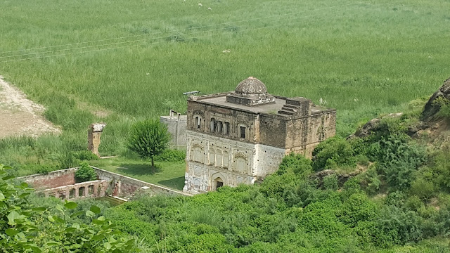
View of the Gurdwara Choa Sahib from Talaqi gate. (18.08.2015.)
Three storey building of gurdwara Choa sahib. (18.08.2015.)
View of Talaqi gate from the gurdwara. (18.08.2015.)
View of the sarovar from the roof of the gurdwara. (18.08.2015.)
Ground floor of the gurdwara. (18.08.2015.)
View from the first floor. (18.08.2015.)
After the partition, a water pump was installed here. Now that has been shifted to its own building nearby. (18.08.2015.)
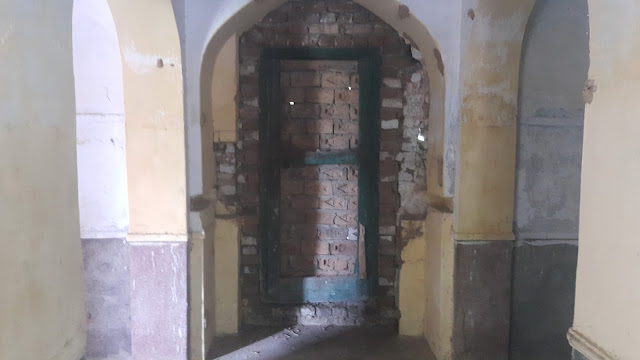
A closed door of the gurdwara Choa sahib. (18.08.2015.)
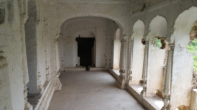
A corridor on the first floor. (18.08.2015.)
A view of the upper floors. (18.08.2015.)
A view of the upper floors. (18.08.2015.)
A view of the upper floors. (18.08.2015.)
North-eastern corner of the gurdwara.
View from the north. (18.08.2015.)
View from the north. (18.08.2015.)
Gurdwara Choa sahib with Talaqi gate in the background. (18.08.2015.)
Now it was almost 12:30, and the real feel temperature was 48°C. By then, my companion Nasir and I were so completely exhausted that it became extremely difficult for us to walk back to our car, just half a kilometer away. A slight ascent of 25 meters became a big challenge for us. Bhola was just smiling at our condition and advising us not to go on an adventure in such weather. But that advice came too late. We twice sat under the shade of bushes and drank whatever little water we had.
To drop Bhola off, we again entered Rohtas and asked him to find cold lemon water for us, as I was not in the mood to drink plain water or even my favourite drink, Pepsi. He said that in that case, we should go to his home. After a little hesitation and on his insistence, we went to his home, which was close by. It was a load-shedding (power cut) time, but the interior of the house was more comfortable than outside. Luckily, power came back in ten minutes, and in the meantime, Bhola’s wife brought a jug full of cold Rooh Afza with lemon added. Needless to say, that was the most delicious drink I have ever had in my life. We stayed there for almost half an hour. Bhola and his wife insisted on preparing lunch for us, but after properly thanking them for their hospitality, we took our leave.
If anybody goes to Rohtas, I suggest taking Bhola as a guide, and I also request the visitor to thank Bhola on my behalf and give him a message that I have not forgotten his hospitality. Ghulam Mustafa (Bhola) can be contacted at +92 332 583 2019.
These two gurdwaras have great importance in the history of Sikhs. Anyone visiting Rohtas Fort should not miss these two historic landmarks.
Tariq Amir
October 28, 2015.
Doha - Qatar.
Update - 1
Several years later, on 16 January 2022, I found myself again in front of the Gurdwara Choa Sahib, but this time the situation was different. Restoration work was in full swing by the Ranjit Nagara Organization. Though it was not complete yet, the difference was very much obvious. The Gurdwara had regained its original beauty to a great extent. This time too, Bhola was there to help and guide. I don't have much to add, except some beautiful pictures of this historic Gurdwara.
Gurdwra Choa Sahib. (16.01.2022.)
Gurdwra Choa Sahib and the Qatali Gate. (16.01.2022.)
Gurdwra Choa Sahib and the Qatali Gate. (16.01.2022.)
Beautiful facade of the gurdwara. (16.01.2022.)
The sarovar. (16.01.2022.)
A corridor on the first floor. (16.01.2022.)
The central room on the first floor. (16.01.2022.)
Windows in facing of south. (16.01.2022.)
Windows facing of south. (16.01.2022.)
A beautiful cupola on roof. (16.01.2022.)
On the roof looking south. The Nala Kahan flows just across the fields. (16.01.2022.)
A side view of the gurdwara. (16.01.2022.)
Ranjit Nagara Organization is undertaking this restoration work. (16.01.2022.)
Gurdwara Choa Sahib Ji
While travelling towards Mecca Guru Nanak Dev Ji reached Rohtas. He arrived here from Tilla Jogian. Tilla Jogian is 3 kos (about 24 kms) from Rohtas Fort. After a long journey by foot in the summer Mardana felt too thirsty. He requested Guru Nanak Dev Ji, “Lord, in this area water is a rare commodity. Humans, animals and birds all are affected by the scarcity.” Guru Nanak Dev Ji then struck the earth with his cane and moved a stone and there appeared a spring of cool, clean and fresh water and small rivulets started running from it. Water spring is called “Choa” (Choa is local word that means spring), hence this place got the name “Choa Sahib”. Even today the residents of the fort use the water of this spring. Sher Shah Suri (about 25 years later) built a magnificent fort adjacent to Gurdwara. The sacred site of Gurdwara Choa Sahib Ji showing its splendour outside Kabuli Darwaza (gate) of Rohtas fort is on the bank of River Ghan. Making use of the water of the spring Sher Shah Suri built the fort in 1541 after he removed Humayun from his territory and with an aim to stop attacks from Durranis he staged his army at the camp. The spring could not be brought in to the complex of the fort despite of three attempts as it sprang out of the fort every time. Now it is outside the western gate of the fort. Guru Hargobind Sahib Ji (6th Guru) has also visited this Gurdwara. Sardar Charat Singh made a concrete tank and a room where Sri Guru Granth Sahib Ji was established. He allotted an old village as jagir which however was declassified by the British. The Gurdwara was constructed outside Kabuli gate. The present building was constructed in 1834 on the orders of Maharaja Ranjit Singh. It is a beautiful building with River Ghan on one side and the fort on the other with forest around the remaining sides. The access to the building is from inside the fort. The shrine presents fascinating natural beauty surrounded by Ghan Nadi (stream), fort, large trees and undergrowth. Rohtas Fort is a famous historical place of sub-continent that is just 4 kilometers from Dina (from main GT road) and then further just 1 km is Gurdwara Choa Sahib Ji. Maharaja Ranjit Singh has assigned 27 ghumaon of land and Rs. 260 to it. Fair is held on the 15th of Katak Sudi. There are 32 windows that keep the Gurdwara enlightened for the whole day. Due to its thickness of the outer walls (4 feet) that makes it all weather house. The serenity within and in the surroundings of Gurdwara along with its superb landscapes is the unique place on earth.
%20-%20Gurdwara%20Choa%20Sahib.jpg)
The Qatali Gate of Rohtas Fort. (16.01.2022.)
Rohtas Fort. (16.01.2022.)
It was encouraging to see that this historic and beautiful Gurdwara is finally being restored and renovated to its original beauty and splendour. I hope that by now the work has been completed, and visitors coming to this place recently are admiring the building and its surroundings as much as it deserves.
Tariq Amir 

















%20-%20Gurdwara%20Choa%20Sahib.jpg)
%20-%20Gurdwara%20Choa%20Sahib.jpg)
%20-%20Gurdwara%20Choa%20Sahib.jpg)
%20-%20Gurdwara%20Choa%20Sahib.jpg)
%20-%20Gurdwara%20Choa%20Sahib.jpg)
%20-%20Gurdwara%20Choa%20Sahib.jpg)
%20-%20Gurdwara%20Choa%20Sahib.jpg)
%20-%20Gurdwara%20Choa%20Sahib.jpg)
%20-%20Gurdwara%20Choa%20Sahib.jpg)
%20-%20Gurdwara%20Choa%20Sahib.jpg)
%20-%20Gurdwara%20Choa%20Sahib.jpg)
%20-%20Gurdwara%20Choa%20Sahib.jpg)
%20-%20Gurdwara%20Choa%20Sahib.jpg)
%20-%20Gurdwara%20Choa%20Sahib.jpg)
%20-%20Gurdwara%20Choa%20Sahib.jpg)
%20-%20Gurdwara%20Choa%20Sahib.jpg)